


NHC tracking 3 features …
(1) T.D. Chris
– moved inland over Mexico overnight
– will continue to weaken and dissipate later today
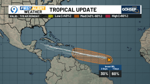
(2) Invest 96L
– likely gets the ‘upgrade’ to Debby within the next 72 hours
– track forecast follows very similar path to Beryl
(3) Category 4 Beryl (as of 8AM)
– after a brief weakening and eyewall replacement cycle, Beryl has returned to Category 4 intensity
– expected to weaken as it crosses the Caribbean due to wind shear … while NHC drops Beryl to a ‘Cat 2’ as it crosses the Caribbean, the amount of weakening remains a bit uncertain … A stronger Beryl would tend to track slightly farther to the north but that would also tend to bring the topography of the Greater Antilles into play
– likely makes landfall near or south of the Yucatan
– possibly re-emerges into the Bay of Campeche over the upcoming weekend after considerable weakening as it crosses land
– most probably Gulf landfall will be in Mexico (it would be their 3rd ‘hit’ this season) or South Texas
– currently a very, VERY low potential for a Louisiana landfall … but not ‘zero’ just yet … Louisiana interests need to monitor Beryl but not become alarmed
Beryl is already in the record books. Preliminary review indicates that Beryl may be the earliest Category 4 on record (back to the 1850s) and the first hurricane forming east of the Lesser Antilles this early in the tropical season.
Keep in mind that while NHC forecasting of tropical tracks continues to improve, intensity forecasts have shown only marginal improvements over the last several years. However, NHC forecasting generally out-performs all models over the course of a hurricane season.
This is a good time to remind everyone to get their hurricane preps for the season finalized … getagameplan.org


Leave a Reply