Good afternoon everyone,
This will be an exciting week for us in Louisiana. The LABEOC staff wanted to send this note before it gets lost in the election news cycle.

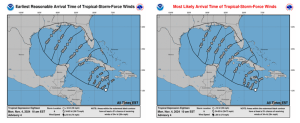
This morning the National Hurricane Center issued an alert for Potential Tropical Cyclone 18 (to be named Rafael in the next 48 hours, most likely). As you can see from the NHC 18 graphic below, there is a lot of uncertainty about the track beyond the next 72 hours.
The Louisiana coastline has a greater than 50% chance of seeing a landfall with this system. The upper weather patterns show a high probability for shear as the storm approaches the coast along with cooling waters near the coast suggesting that it is unlikely to be a strong system when (or if) it hits the Louisiana coast. The earliest that the storm’s effects will reach Louisiana is Thursday evening, with the most likely scenario being Friday late morning. As you can see from the second graphic the width of the arrival time shows the width of the uncertainty of the landfall.
As more information about this system becomes available, I will share it with all of you.
Respectfully,
Jim Williams, LEM-B, MBA
Public-Private Partnership Operations Officer
( Office: (337) 482-0633


Leave a Reply